|
|
|
 |
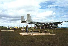
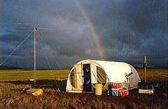
Ivotuk, North Slope Alaska |
|
|
|
|
Ivotuk, North Slope Alaska |
|
This BLM project involved locating the Pet-4 Naval Petroleum reserve’s western boundary. Doppler satellite technology was used to collect project data and processing was done in Anchorage, Alaska, by network connection to Denver, Colorado. The field crew consisted of Ms. Hartel, Mr. Moistner, helicopter pilot, and mechanic. An Armstrong-Whitworth Argosy aircraft was contracted to fly camp and survey supplies to Ivotuk, a bare landing strip, 80 miles Northeast of Anatuvik Pass and 100 miles North of the arctic circle. The Argosy was chosen because of its long range and large payload capability, but careful planning was still necessary. Weight restrictions in the Argosy limited the amount of Jet-A fuel that could be flown in with the camp and survey supplies. After the initial camp was set up, a radio repeater was positioned on a mountain peak such that it would cover the project area and maintain radio communications between the base of operations at Ivotuk and the helicopter. A Meteor Burst communications system was set up at Ivotuk so as to maintain a communication link with the BLM in Anchorage. After an adequate number of satellite passes had been collected at each of the control stations a message was sent to Anchorage and arrangement were made for a charter airplane to pick up Ms. Hartel and the data for processing in Anchorage. After processing the control positions, Ms. Hartel flew back to Ivotuk to finish the survey and set the monumentation. Even with a trip to Anchorage to process the data and deteriorating weather conditions. The project was successfully completed within its four week projected time frame. |
click on image for larger view
|
 |
|